In early 1827, during her first voyage in South America, under the command of Captain Pringle Stokes, HMS Beagle was beating a hasty retreat from storms in the Strait of Magellan when she struck a submerged rock near Port Desire, damaging a large section of her false keel.
In December 1833, during her second voyage, under Captain Robert FitzRoy, Beagle was leaving Port Desire when she once again struck a rock. FitzRoy was convinced it was the same rock.
Charged with accurately mapping the South American coast for shipping, the ever-fastidious captain returned to the spot the following month to try to locate the rock, but to no avail. The ship’s carpenter, Jonathan May, assured FitzRoy that Beagle must have knocked the top off the rock with her keel.
Being about to pass through the Strait of Magellan, FitzRoy did not want to risk having a damaged hull on his ship. Although Beagle was still watertight, any damage to her copper sheathing would leave her timbers open to attack from the South Pacific’s notorious wood-boring worms.
One of the books in Beagle’s well-stocked library was the sealer and Antarctic explorer James Weddell’s snappily entitled:
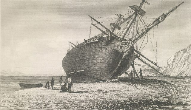
Weddell’s book did indeed contain much useful information. In one section about the Santa Cruz River he wrote, “The rise of the tide is so great in this river, being thirty-two feet, that the keel of the largest ship may be examined, by laying her on the ground.” FitzRoy decided it was time to inspect Beagle’s keel. He made for the Santa Cruz and, on 16th April 1834, Charles Darwin recorded in his Beagle Journal:
16th The Ship was laid on shore; it was found that several feet of her false keel were knocked off, but this is no essential damage; one tide was sufficient to repair her & after noon she floated off & was again moored in safety. Nothing could be more favourable than both the weather & place for this rather ticklish operation. —
The event gave us one of the most iconic images of HMS Beagle: this magnificent engraving based on a sketch by Beagle’s newly installed artist in residence, Conrad Martens:
To commemorate the event, FitzRoy named the spot at which they beached Beagle Keel Point. He calculated the point’s latitude and ‘relatively right’ longitude to be: 50° 06′ 45″ S and 4h 33m 34s W respectively. This converts into decimal as 50.1125°S and 68.3917°W, the point indicated by the pin on this clickable Google Map:
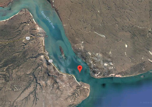
FitzRoy’s calculations were pretty spot-on. The beach with the jetty to the south west of the pin is still known as Punta Quilla (Keel Point).
I wonder if the good people of Punta Quilla know how their beach got its name.
Sources:
- HMS Beagle: The ship that changed the course of history by Keith S Thomson
- The Correspondence of Charles Darwin, volume 1: 1821–1836, Appendix IV, The books on board the Beagle
- The Complete Work of Charles Darwin Online
- Google Maps

Leave a Reply